National Register of Historic Places listings in Martinsville, Virginia
This is a list of the National Register of Historic Places listings in Martinsville, Virginia.
This is intended to be a complete list of the properties and districts on the National Register of Historic Places in the independent city of Martinsville, Virginia, United States. The locations of National Register properties and districts for which the latitude and longitude coordinates are included below, may be seen in an online map.[1]
There are 8 properties and districts listed on the National Register in the city.
This National Park Service list is complete through NPS recent listings posted July 5, 2024.[2]
Map all coordinates using OpenStreetMap
Download coordinates as:
- KML
- GPX (all coordinates)
- GPX (primary coordinates)
- GPX (secondary coordinates)
Current listings
| [3] | Name on the Register[4] | Image | Date listed[5] | Location | Description |
|---|---|---|---|---|---|
| 1 | John Waddey Carter House |  | November 3, 1988 (#88002180) | 324 E. Church St. 36°41′18″N 79°51′55″W / 36.688333°N 79.865278°W / 36.688333; -79.865278 (John Waddey Carter House) | Designed by architect George Franklin Barber |
| 2 | Dry Bridge School |  | February 25, 2009 (#09000065) | 1005 Jordan St. 36°41′31″N 79°50′55″W / 36.692083°N 79.848750°W / 36.692083; -79.848750 (Dry Bridge School) | |
| 3 | East Church Street-Starling Avenue Historic District | 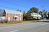 | September 6, 2006 (#06000805) | Brown St., E. Church St., Cleveland Ave., Letcher Court, E. Market St., Scuffle Hill, and Starling Ave. 36°41′18″N 79°51′51″W / 36.688333°N 79.864167°W / 36.688333; -79.864167 (East Church Street-Starling Avenue Historic District) | |
| 4 | Fayette Street Historic District |  | May 2, 2007 (#07000395) | Fayette St. and side streets roughly bounded by Market, W. Church, Memorial and Swanson Sts. 36°41′33″N 79°52′54″W / 36.692489°N 79.881542°W / 36.692489; -79.881542 (Fayette Street Historic District) | |
| 5 | Little Post Office |  | February 21, 1997 (#97000150) | 207 Starling Ave. 36°41′05″N 79°51′56″W / 36.684861°N 79.865556°W / 36.684861; -79.865556 (Little Post Office) | |
| 6 | Martinsville Historic District |  | October 30, 1998 (#98001317) | Roughly bounded by State Route 457, the former Danville Railroad tracks, Clay St., and Market St.; also Fayette, Church, Market, Moss, Bridge, Broad, and Ellsworth Sts., Cleveland Ave. 36°41′30″N 79°52′21″W / 36.691667°N 79.872500°W / 36.691667; -79.872500 (Martinsville Historic District) | Boundary changes were approved on December 27, 2022. |
| 7 | Martinsville Novelty Corporation Factory |  | May 21, 2010 (#10000282) | 900 Rives Rd. 36°40′36″N 79°51′41″W / 36.676667°N 79.861389°W / 36.676667; -79.861389 (Martinsville Novelty Corporation Factory) | |
| 8 | Scuffle Hill |  | February 21, 1997 (#97000158) | 311 E. Church St. 36°41′22″N 79°51′57″W / 36.689444°N 79.865972°W / 36.689444; -79.865972 (Scuffle Hill) |
See also
Wikimedia Commons has media related to National Register of Historic Places in Martinsville, Virginia.
- List of National Historic Landmarks in Virginia
- National Register of Historic Places listings in Virginia
References
- ^ The latitude and longitude information provided in this table was derived originally from the National Register Information System, which has been found to be fairly accurate for about 99% of listings. Some locations in this table may have been corrected to current GPS standards.
- ^ National Park Service, United States Department of the Interior, "National Register of Historic Places: Weekly List Actions", retrieved July 5, 2024.
- ^ Numbers represent an alphabetical ordering by significant words. Various colorings, defined here, differentiate National Historic Landmarks and historic districts from other NRHP buildings, structures, sites or objects.
- ^ "National Register Information System". National Register of Historic Places. National Park Service. April 24, 2008.
- ^ The eight-digit number below each date is the number assigned to each location in the National Register Information System database, which can be viewed by clicking the number.
- v
- t
- e
by county
- Accomack
- Albemarle
- Alleghany
- Amelia
- Amherst
- Appomattox
- Arlington
- Augusta
- Bath
- Bedford
- Bland
- Botetourt
- Brunswick
- Buchanan
- Buckingham
- Campbell
- Caroline
- Carroll
- Charles City
- Charlotte
- Chesterfield
- Clarke
- Craig
- Culpeper
- Cumberland
- Dickenson
- Dinwiddie
- Essex
- Fairfax
- Fauquier
- Floyd
- Fluvanna
- Franklin
- Frederick
- Giles
- Gloucester
- Goochland
- Grayson
- Greene
- Greensville
- Halifax
- Hanover
- Henrico
- Henry
- Highland
- Isle Of Wight
- James City
- King and Queen
- King George
- King William
- Lancaster
- Lee
- Loudoun
- Louisa
- Lunenburg
- Madison
- Mathews
- Mecklenburg
- Middlesex
- Montgomery
- Nelson
- New Kent
- Northampton
- Northumberland
- Nottoway
- Orange
- Page
- Patrick
- Pittsylvania
- Powhatan
- Prince Edward
- Prince George
- Prince William
- Pulaski
- Rappahannock
- Richmond
- Roanoke
- Rockbridge
- Rockingham
- Russell
- Scott
- Shenandoah
- Smyth
- Southampton
- Spotsylvania
- Stafford
- Surry
- Sussex
- Tazewell
- Warren
- Washington
- Westmoreland
- Wise
- Wythe
- York

by city
- Alexandria
- Bristol
- Buena Vista
- Charlottesville
- Chesapeake
- Colonial Heights
- Covington
- Danville
- Emporia
- Fairfax
- Falls Church
- Franklin
- Fredericksburg
- Galax
- Hampton
- Harrisonburg
- Hopewell
- Lexington
- Lynchburg
- Manassas
- Manassas Park
- Martinsville
- Newport News
- Norfolk
- Norton
- Petersburg
- Poquoson (no listings)
- Portsmouth
- Radford
- Richmond
- Roanoke
- Salem
- Staunton
- Suffolk
- Virginia Beach
- Waynesboro
- Williamsburg
- Winchester


