National Register of Historic Places listings in Jay County, Indiana

This is a list of the National Register of Historic Places listings in Jay County, Indiana.
This is intended to be a complete list of the properties and districts on the National Register of Historic Places in Jay County, Indiana, United States. Latitude and longitude coordinates are provided for many National Register properties and districts; these locations may be seen together in a map.[1]
There are 8 properties and districts listed on the National Register in the county.
Properties and districts located in incorporated areas display the name of the municipality, while properties and districts in unincorporated areas display the name of their civil township. Properties and districts split between multiple jurisdictions display the names of all jurisdictions.
This National Park Service list is complete through NPS recent listings posted June 7, 2024.[2]
Map all coordinates using OpenStreetMap
Download coordinates as:
- KML
- GPX (all coordinates)
- GPX (primary coordinates)
- GPX (secondary coordinates)
Current listings
| [3] | Name on the Register[4] | Image | Date listed[5] | Location | City or town | Description |
|---|---|---|---|---|---|---|
| 1 | Floral Hall |  | September 1, 1983 (#83000038) | E. Votaw and Morton Sts. at the Jay County Fairgrounds, east of Portland[6] 40°26′29″N 84°58′04″W / 40.441389°N 84.967778°W / 40.441389; -84.967778 (Floral Hall) | Wayne Township | |
| 2 | Grouping of Religious Buildings at Trinity |  | October 23, 1980 (#80000040) | Northeast of Portland at Trinity 40°32′29″N 84°50′28″W / 40.541389°N 84.841111°W / 40.541389; -84.841111 (Grouping of Religious Buildings at Trinity) | Wabash Township | |
| 3 | James Haines Farm |  | March 15, 2000 (#00000202) | County Road 869E 200S, southeast of Portland 40°23′39″N 84°57′25″W / 40.394167°N 84.956944°W / 40.394167; -84.956944 (James Haines Farm) | Pike Township | |
| 4 | Jay County Courthouse |  | May 12, 1981 (#81000016) | U.S. Route 27 40°26′01″N 84°58′43″W / 40.433611°N 84.978611°W / 40.433611; -84.978611 (Jay County Courthouse) | Portland | |
| 5 | Portland Commercial Historic District | 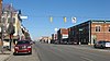 | May 30, 1996 (#96000600) | Roughly Meridian St. from Arch St. to the S. Meridian St. Bridge, and Main and Walnut Sts. from Ship to Court Sts. 40°26′00″N 84°58′48″W / 40.433333°N 84.980000°W / 40.433333; -84.980000 (Portland Commercial Historic District) | Portland | |
| 6 | Rebecca Rankin Round Barn |  | April 2, 1993 (#93000189) | State Road 18, ¼ mile west of its junction with County Road 75E, and northwest of Poling 40°33′16″N 85°06′40″W / 40.554444°N 85.111111°W / 40.554444; -85.111111 (Rebecca Rankin Round Barn) | Penn Township | |
| 7 | Redkey Historic District |  | September 17, 1992 (#92001168) | Roughly High St. between Oak and Meridian Sts. 40°20′59″N 85°09′07″W / 40.349722°N 85.151944°W / 40.349722; -85.151944 (Redkey Historic District) | Redkey | |
| 8 | Jonas Votaw House |  | December 6, 2004 (#04001308) | 1525 S. Meridian St. 40°24′47″N 84°58′34″W / 40.413056°N 84.976111°W / 40.413056; -84.976111 (Jonas Votaw House) | Portland |
See also
Wikimedia Commons has media related to National Register of Historic Places in Jay County, Indiana.
- List of National Historic Landmarks in Indiana
- National Register of Historic Places listings in Indiana
- Listings in neighboring counties: Adams, Blackford, Darke (OH), Delaware, Mercer (OH), Randolph, Wells
References
- ^ The latitude and longitude information provided in this table was derived originally from the National Register Information System, which has been found to be fairly accurate for about 99% of listings. Some locations in this table may have been corrected to current GPS standards.
- ^ National Park Service, United States Department of the Interior, "National Register of Historic Places: Weekly List Actions", retrieved June 7, 2024.
- ^ Numbers represent an alphabetical ordering by significant words. Various colorings, defined here, differentiate National Historic Landmarks and historic districts from other NRHP buildings, structures, sites or objects.
- ^ "National Register Information System". National Register of Historic Places. National Park Service. March 13, 2009.
- ^ The eight-digit number below each date is the number assigned to each location in the National Register Information System database, which can be viewed by clicking the number.
- ^ Division of Historic Preservation and Archaeology. Jay County Interim Report. Indianapolis: Indiana Department of Natural Resources, 1985-07, 18. The NRIS lists the site at the nonexistent intersection of W. Votaw [sic] and Moton [sic] Sts.
- v
- t
- e
- List of U.S. National Historic Landmarks by state:
- Alabama
- Alaska
- Arizona
- Arkansas
- California
- Colorado
- Connecticut
- Delaware
- Florida
- Georgia
- Hawaii
- Idaho
- Illinois
- Indiana
- Iowa
- Kansas
- Kentucky
- Louisiana
- Maine
- Maryland
- Massachusetts
- Michigan
- Minnesota
- Mississippi
- Missouri
- Montana
- Nebraska
- Nevada
- New Hampshire
- New Jersey
- New Mexico
- New York
- North Carolina
- North Dakota
- Ohio
- Oklahoma
- Oregon
- Pennsylvania
- Rhode Island
- South Carolina
- South Dakota
- Tennessee
- Texas
- Utah
- Vermont
- Virginia
- Washington
- West Virginia
- Wisconsin
- Wyoming
 National Register of Historic Places portal
 Category


