Montopolis Bridge
Historic bridge in Austin, Texas
30°14′44″N 97°41′29″W / 30.24542°N 97.69136°W / 30.24542; -97.69136 US 183 frontage road)
Montopolis Bridge


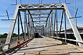
The Montopolis Bridge is a historic Parker through truss bridge in Austin, Texas. It is located in the Montopolis neighborhood where a bicycle and pedestrian walkway crosses the Colorado River in southeastern Travis County. The bridge consists of five 200-foot Parker through truss spans and four 52-foot steel I-beam approach spans resting on reinforced concrete abutments. It was added to the National Register of Historic Places on October 10, 1996.[2]
History
On June 15, 1935, the city of Austin suffered a devastating flood along the Colorado River. The original Montopolis bridge, built by Travis County in the late 1880s, was one of five bridges washed away by the flood. The Texas Highway Department designed the current bridge and requested federal emergency relief funds from the Bureau of Public Roads to rebuild it.[3] Work on the bridge began on February 15, 1937. The bridge was completed on February 11, 1938, by Vincennes Steel Corporation under contract to the Highway Department at a cost of nearly $232,000 (equivalent to $5,020,000 in 2023).[4]
The Montopolis Bridge remained in use until 2018 and, as one of the principal routes to the Austin-Bergstrom International Airport from Downtown Austin, was fairly busy. The southbound frontage of U.S. 183, Airport Boulevard and East 7th Street all merge at the north side of the bridge. In 2006, 29,200 vehicles crossed on average each day. The bridge was decommissioned for vehicular traffic on October 8, 2018,[5] and was subsequently converted to a bicycle and pedestrian bridge as part of the Bergstrom Expressway Project.[6]
-
 Deck during conversion to pedestrian use in 2020
 -
 Austin skyline from the bridge
 -
 The Colorado River in the Montopolis area


See also
- List of crossings of the Colorado River
- National Register of Historic Places listings in Travis County, Texas
- List of bridges on the National Register of Historic Places in Texas
References
- ^ "National Register Information System". National Register of Historic Places. National Park Service. July 9, 2010.
- ^ "Montopolis Bridge". Bridgehunter.com. Retrieved November 24, 2011.
- ^ Montopolis Bridge. Texas Historic Sites Atlas. Texas Historical Commission.
- ^ "Montopolis Bridge". Find the Data. Retrieved November 23, 2011.
- ^ "Major Activity - 183 South". Archived from the original on October 14, 2018.
- ^ Huber, Mary (October 16, 2019). "Montopolis Bridge in East Austin gets facelift before opening for hike-and-bike trail". Austin American-Statesman. Retrieved January 14, 2020.
External links
 Media related to Montopolis Bridge at Wikimedia Commons
Crossings of the Colorado River | ||||
|---|---|---|---|---|
| ||||

- v
- t
- e
Slogan: Live Music Capital of the World
- 1839 city plan
- 1928 city plan
- Austin Dam failure
- Capitol View Corridors
- COVID-19 pandemic
- French Legation
- Greater Austin
- Stephen F. Austin
- Texas Archive War
- Timeline
- Treaty Oak
- Waterloo, Texas
| Tertiary | |||
|---|---|---|---|
| School districts | |||
| State schools |
| ||
| Libraries |
| General | |
|---|---|
| Creative arts | |
| Technology |
- Arthouse at Laguna Gloria
- Arthouse at The Jones Center
- Austin History Center
- Austin Museum of Digital Art
- Blanton Museum of Art
- Bullock Texas State History Museum
- The Contemporary Austin
- Dolph Briscoe Center for American History
- Elisabet Ney Museum
- French Legation Museum
- George Washington Carver Museum and Cultural Center
- Harry Ransom Humanities Research Center
- Jacob Fontaine Religious Museum
- Lady Bird Johnson Wildflower Center
- Lyndon Baines Johnson Library and Museum
- Mexic-Arte Museum
- Neill-Cochran House Museum
- O. Henry Museum
- South Austin Museum of Popular Culture
- Texas Memorial Museum
- Texas Military Forces Museum
- Texas State Capitol Visitors Center
- Umlauf Sculpture Garden and Museum
- Women and Their Work
- Allandale
- Anderson Mill
- Barton Hills
- Blackland
- Bouldin Creek
- Bremond Block Historic District
- Brentwood
- Bryker Woods
- Canyon Creek
- Chinatown
- Circle C Ranch
- Clarksville
- Congress Avenue
- Copperfield
- Crestview
- Dawson
- Dove Springs
- Downtown Austin
- The Drag
- East Cesar Chavez
- East Riverside-Oltorf
- Easton Park
- French Place
- Galindo
- Granada Hills
- Hancock
- Hyde Park Historic District
- Jollyville
- Montopolis
- Moore's Crossing Historic District
- Mueller Community
- North Burnet–Gateway
- North Shoal Creek
- Northwest Hills
- Oak Hill
- Old West Austin
- Onion Creek
- Pemberton Heights
- Rainey Street
- Rosedale
- Saint John
- Scenic Brook
- Shadow Lawn Historic District
- Sixth Street
- South Congress
- South Lamar
- South River City
- Spyglass-Barton's Bluff
- Swedish Hill
- Tarrytown
- Travis Heights
- Waters Park
- West Campus
- Westgate
- West Line
- Willow-Spence Streets
- Windsor Hills
- Windsor Park
- Wooten
- Zilker
recreation
- Auditorium Shores
- Barton Creek
- Barton Springs
- Big Walnut Creek
- Bull Creek
- Colorado River
- Deep Eddy Pool
- Emma Long
- Hippie Hollow
- Lady Bird Lake
- Lake Austin
- Lake Travis
- Lake Walter E. Long
- McKinney Falls
- Mount Bonnell
- Pease Park
- Republic Square
- Rosewood Park
- Walnut Creek Park
- Wild Basin
- Zilker Park
| Public | |
|---|---|
| Freeways | |
| Streets |
|
| Bridges |


