List of lighthouses in the Isle of Man
Map all coordinates using OpenStreetMap
Download coordinates as:
- KML
- GPX (all coordinates)
- GPX (primary coordinates)
- GPX (secondary coordinates)
This is a list of lighthouses in the Isle of Man which is located in the Irish Sea between England and Ireland.[1]
Lighthouses
| Lighthouse | Image | Location coordinates | Year built | Tower height | Focal height | Range | Notes |
|---|---|---|---|---|---|---|---|
| Calf of Man (low) |  | Calf of Man 54°03.157′N 4°49.734′W / 54.052617°N 4.828900°W / 54.052617; -4.828900 | 1815 | 15 m (49 ft) | 86 m (282 ft) | Inactive | Designed by Robert Stevenson. Inactive since 1875 |
| Calf of Man (high) |  | Calf of Man 54°03.180′N 4°49.715′W / 54.053000°N 4.828583°W / 54.053000; -4.828583 | 1815/1968 | 18 m (59 ft) | 93 m (305 ft) | Inactive | Designed by Robert Stevenson. Inactive since 2007 |
| Castletown Harbour: Irish Quay |  | Castletown 54°04′21″N 4°39′00″W / 54.0724°N 4.6499°W / 54.0724; -4.6499 (Castletown) | 1944 | 3.5 m (11 ft) | 5 m (16 ft) | 5 nmi (9 km) | Operated by Isle of Man Harbours |
| Castletown Harbour: New Pier | 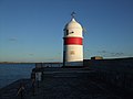 | Castletown 54°04′21″N 4°39′00″W / 54.0724°N 4.6499°W / 54.0724; -4.6499 (Castletown) | 1849 | 7 m (23 ft) | 8 m (26 ft) | 5 nmi (9 km) | Operated by Isle of Man Harbours |
| Chicken Rock |  | Chicken Rock 54°02.271′N 4°50.315′W / 54.037850°N 4.838583°W / 54.037850; -4.838583 | 1875 | 44 m (144 ft) | 38 m (125 ft) | 21 nmi (39 km) | Designed by David & Thomas Stevenson |
| Douglas Head |  | Douglas Head 54°08.599′N 4°27.947′W / 54.143317°N 4.465783°W / 54.143317; -4.465783 | 1857 | 20 m (66 ft) | 32 m (105 ft) | 24 nmi (44 km) | Designed by David & Thomas Stevenson |
| Langness |  | Dreswick Point 54°03′14″N 4°37′30″W / 54.05389°N 4.62500°W / 54.05389; -4.62500 | 1880 | 19 m (62 ft) | 23 m (75 ft) | 12 nmi (22 km) | Designed by David & Thomas Stevenson |
| Maughold Head |  | Maughold Head 54°17.734′N 4°18.585′W / 54.295567°N 4.309750°W / 54.295567; -4.309750 | 1914 | 23 m (75 ft) | 65 m (213 ft) | 21 nmi (39 km) | Designed by Charles Stevenson |
| Point of Ayre |  | Point of Ayre 54°24.959′N 4°22.111′W / 54.415983°N 4.368517°W / 54.415983; -4.368517 | 1818 | 30 m (98 ft) | 32 m (105 ft) | 19 nmi (35 km) | Designed by Robert Stevenson |
| Point of Ayre Winkie |  | Point of Ayre 54°24.959′N 4°22.111′W / 54.415983°N 4.368517°W / 54.415983; -4.368517 | 1888 | 10 m (33 ft) | 10 m (33 ft) | Inactive | Inactive since 2010 |
| Port Erin Range Front | 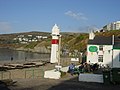 | Port Erin 54°05′14″N 4°45′34″W / 54.0872°N 4.7594°W / 54.0872; -4.7594 | Unknown | 11 m (36 ft) | 10 m (33 ft) | 5 nmi (9 km) | Operated by Isle of Man Harbours |
| Thousla Rock |  | Calf Sound 54°03′44″N 4°48′02″W / 54.06215°N 4.80065°W / 54.06215; -4.80065 (Thousla) | 1981 | 9 m (30 ft) | 9 m (30 ft) | 4 nmi (7 km) | Octagonal pillar, displays a flashing red light. |
See also
- Registered Buildings and Conservations Areas of the Isle of Man
- List of Northern Lighthouse Board lighthouses
- List of lighthouses in the United Kingdom
- Lists of lighthouses and lightvessels
References
- ^ Rowlett, Russ. "Lighthouses of the Isle of Man". The Lighthouse Directory. University of North Carolina at Chapel Hill. Retrieved 5 July 2015.
External links
Wikimedia Commons has media related to Lighthouses in the Isle of Man.
- Rowlett, Russ. "The Lighthouse Directory". University of North Carolina at Chapel Hill.
Portals:
 Engineering
 Architecture
 Lists
Lists


- v
- t
- e
Lighthouses and lightvessels in Europe
- Albania
- Austria
- Azerbaijan
- Belgium
- Bosnia and Herzegovina
- Bulgaria
- Croatia
- Cyprus
- Denmark
- Estonia
- Finland
- France
- Georgia
- Germany
- Greece
- Iceland
- Ireland
- Italy
- Kazakhstan
- Latvia
- Lithuania
- Malta
- Monaco
- Montenegro
- Netherlands
- Norway
- Poland
- Portugal
- Romania
- Russia
- Slovenia
- Spain
- Sweden
- Switzerland
- Turkey
- Ukraine
- United Kingdom
States with limited
recognition
recognition
Dependencies and
other territories
other territories
 Europe portal


