List of National Historic Landmarks in Kentucky
This is a complete list of National Historic Landmarks in Kentucky.[1] There are 32 such landmarks in Kentucky; one landmark has had its designation withdrawn.
Map all coordinates using OpenStreetMap
Download coordinates as:
- KML
- GPX (all coordinates)
- GPX (primary coordinates)
- GPX (secondary coordinates)
| [2] | Landmark name | Image | Date designated[3] | Location | County | Description |
|---|---|---|---|---|---|---|
| 1 | Daniel C. Beard Boyhood Home | 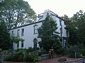 | June 23, 1965 (#66000360) | Covington 39°05′21″N 84°30′20″W / 39.089167°N 84.50556°W / 39.089167; -84.50556 (Daniel C. Beard Boyhood Home) | Kenton | Home of Daniel Carter Beard, a founder of the Boy Scouts of America |
| 2 | BELLE OF LOUISVILLE (river steamboat) |  | June 30, 1989 (#72000535) | Louisville 38°15′33″N 85°45′20″W / 38.259167°N 85.75556°W / 38.259167; -85.75556 (BELLE OF LOUISVILLE (river steamboat)) | Jefferson | One of the last authentic steamboats in existence |
| 3 | Burks' Distillery | 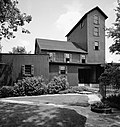 | January 16, 1980 (#74000893) | Loretto 37°38′52″N 85°20′56″W / 37.647778°N 85.348889°W / 37.647778; -85.348889 (Burks' Distillery) | Marion | Producer of Maker's Mark bourbon whiskey |
| 4 | Camp Nelson Historic and Archeological District |  | February 27, 2013 (#13000286) | Nicholasville 37°47′16″N 84°35′53″W / 37.7878°N 84.5981°W / 37.7878; -84.5981 (Camp Nelson Historic and Archeological District) | Jessamine | Military depot and African-American recruitment center for the Union Army |
| 5 | Churchill Downs | 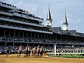 | October 21, 1986 (#78001348) | Louisville 38°12′11″N 85°46′12″W / 38.203056°N 85.77°W / 38.203056; -85.77 (Churchill Downs) | Jefferson | Home of the legendary Kentucky Derby |
| 6 | Henry Clay Home (Ashland) |  | December 19, 1960 (#66000357) | Lexington 38°01′43″N 84°28′48″W / 38.0286°N 84.48°W / 38.0286; -84.48 (Henry Clay Home (Ashland)) | Fayette | Home of Henry Clay |
| 7 | Covington and Cincinnati Suspension Bridge |  | May 15, 1975 (#75000786) | Covington, KY and Cincinnati, OH 39°05′32″N 84°30′34″W / 39.09222°N 84.5094°W / 39.09222; -84.5094 (Covington and Cincinnati Suspension Bridge) | Kenton, KY and Hamilton, OH | Prototype for New York's Brooklyn Bridge |
| 8 | Fort Boonesborough Site |  | June 19, 1996 (#94000303) | Richmond 37°54′02″N 84°16′06″W / 37.900556°N 84.2683°W / 37.900556; -84.2683 (Fort Boonesborough Site) | Madison | One of the original settlements in Kentucky |
| 9 | Green River Shell Middens Archeological District |  | May 5, 1994 (#85003182) | Multiple | Butler, Henderson, McLean, Muhlenberg, and Ohio | 23 Late Archaic period sites |
| 10 | Indian Knoll | Upload image | September 23, 1964 (#66000362) | McHenry | Ohio | Archaic shell midden |
| 11 | Jacobs Hall, Kentucky School for the Deaf |  | December 21, 1965 (#66000354) | Danville 37°38′29″N 84°46′18″W / 37.641389°N 84.77167°W / 37.641389; -84.77167 (Jacobs Hall, Kentucky School for the Deaf) | Boyle | Oldest remaining building at the Kentucky School for the Deaf[4] |
| 12 | Keeneland Race Course |  | September 24, 1986 (#86003487) | Lexington 38°02′44″N 84°36′38″W / 38.04556°N 84.61056°W / 38.04556; -84.61056 (Keeneland Race Course) | Fayette | Race track |
| 13 | Labrot and Graham's Old Oscar Pepper Distillery |  | May 16, 2000 (#95001272) | Versailles 38°06′46″N 84°48′43″W / 38.11278°N 84.8119°W / 38.11278; -84.8119 (Labrot and Graham's Old Oscar Pepper Distillery) | Woodford | Producer of Woodford Reserve bourbon whiskey |
| 14 | Liberty Hall |  | November 11, 1971 (#71000344) | Frankfort 38°11′59″N 84°52′52″W / 38.1997°N 84.8811°W / 38.1997; -84.8811 (Liberty Hall) | Franklin | Home of John Brown, who helped Kentucky attain statehood |
| 15 | Lincoln Hall, Berea College |  | December 2, 1974 (#74000892) | Berea 37°34′19″N 84°17′09″W / 37.57194°N 84.28583°W / 37.57194; -84.28583 (Lincoln Hall, Berea College) | Madison | Building at Berea College, first biracial college in the United States |
| 16 | Locust Grove |  | June 23, 1986 (#71000347) | Louisville 38°17′13″N 85°39′43″W / 38.2869°N 85.6619°W / 38.2869; -85.6619 (Locust Grove) | Jefferson | Former domicile of George Rogers Clark |
| 17 | Louisville Water Company Pumping Station |  | November 11, 1971 (#71000348) | Louisville 38°16′50″N 85°42′04″W / 38.28056°N 85.7011°W / 38.28056; -85.7011 (Louisville Water Company Pumping Station) | Jefferson | Historic water tower and pumping station along the Ohio River |
| 18 | MAYOR ANDREW BROADDUS (Lifesaving Station) |  | June 30, 1989 (#89001446) | Louisville 38°15′33″N 85°45′18″W / 38.259167°N 85.755°W / 38.259167; -85.755 (MAYOR ANDREW BROADDUS (Lifesaving Station)) | Jefferson | Only remaining floating lifestation |
| 19 | Dr. Ephraim McDowell House |  | January 12, 1965 (#66000355) | Danville 37°38′42″N 84°46′16″W / 37.645°N 84.7711°W / 37.645; -84.7711 (Dr. Ephraim McDowell House) | Boyle | Site of first successful ovariotomy, done by Ephraim McDowell |
| 20 | Middle Creek Battlefield |  | October 5, 1992 (#91001665) | Prestonsburg 37°39′01″N 82°48′50″W / 37.650278°N 82.81389°W / 37.650278; -82.81389 (Middle Creek Battlefield) | Floyd | Site of an early Union victory in January 1862, with future President James A. Garfield commanding the Union troops |
| 21 | Mill Springs Battlefield |  | April 19, 1994 (#93000001) | Nancy 37°00′19″N 84°45′28″W / 37.00528°N 84.75778°W / 37.00528; -84.75778 (Mill Springs Battlefield) | Pulaski | Where a Union victory ended Confederate defensive line in Kentucky in 1862 |
| 22 | Old Bank of Louisville |  | November 11, 1971 (#71000349) | Louisville 38°15′20″N 85°45′20″W / 38.25556°N 85.7556°W / 38.25556; -85.7556 (Old Bank of Louisville) | Jefferson | |
| 23 | Old Morrison, Transylvania College |  | December 21, 1965 (#66000358) | Lexington 38°03′09″N 84°29′38″W / 38.0525°N 84.4939°W / 38.0525; -84.4939 (Old Morrison, Transylvania College) | Fayette | One of the first buildings of Transylvania University, the first college built west of the Appalachian Mountains |
| 24 | Old State House | 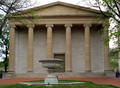 | November 11, 1971 (#71000346) | Frankfort 38°12′01″N 84°52′36″W / 38.20028°N 84.8767°W / 38.20028; -84.8767 (Old State House) | Franklin | |
| 25 | Perryville Battlefield |  | December 19, 1960 (#66000356) | Perryville 37°40′31″N 84°58′11″W / 37.67528°N 84.9697°W / 37.67528; -84.9697 (Perryville Battlefield) | Boyle | Site of largest battle in Kentucky during the American Civil War |
| 26 | Pine Mountain Settlement School |  | December 4, 1991 (#78001337) | Bledsoe 36°56′55″N 83°10′59″W / 36.9486°N 83.18306°W / 36.9486; -83.18306 (Pine Mountain Settlement School) | Harlan | Brought to a rural community an urban settlement house[5] |
| 27 | Shakertown at Pleasant Hill Historic District |  | November 11, 1971 (#71000353) | Harrodsburg 37°49′05″N 84°44′25″W / 37.81806°N 84.74028°W / 37.81806; -84.74028 (Shakertown at Pleasant Hill Historic District) | Mercer | Home of a Shaker community |
| 28 | George T. Stagg Distillery |  | February 27, 2013 (#01000450) | Frankfort 38°13′03″N 84°52′11″W / 38.2175°N 84.8697°W / 38.2175; -84.8697 (George T. Stagg Distillery) | Franklin | Producer of Buffalo Trace bourbon whiskey, a rare example of a distillery that operated before, during, and after Prohibition |
| 29 | Zachary Taylor House | 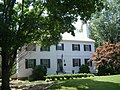 | July 4, 1961 (#66000359) | Louisville 38°16′45″N 85°38′50″W / 38.27917°N 85.6472°W / 38.27917; -85.6472 (Zachary Taylor House) | Jefferson | Home of U.S. President Zachary Taylor |
| 30 | United States Marine Hospital |  | September 25, 1997 (#97001265) | Louisville 38°16′16″N 85°47′03″W / 38.2711°N 85.78417°W / 38.2711; -85.78417 (United States Marine Hospital) | Jefferson | |
| 31 | Wendover (Frontier Nursing Service Headquarters) | 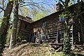 | July 17, 1991 (#75000792) | Hyden 37°07′39″N 83°21′55″W / 37.1275°N 83.36528°W / 37.1275; -83.36528 (Wendover (Frontier Nursing Service Headquarters)) | Leslie | First American attempt to professionalize midwifery |
| 32 | Whitney M. Young Birthplace and Boyhood Home |  | April 27, 1984 (#72000543) | Simpsonville 38°13′22″N 85°22′20″W / 38.2228°N 85.3722°W / 38.2228; -85.3722 (Whitney M. Young Birthplace and Boyhood Home) | Shelby | Birthplace and childhood home of Whitney Young |
See also
- National Register of Historic Places listings in Kentucky
- List of National Historic Landmarks by state
- List of National Natural Landmarks in Kentucky
References
- ^ National Historic Landmarks Archived 2008-07-10 at the Wayback Machine, National Park Service, accessed May, 2006.
- ^ Numbers represent an alphabetical ordering by significant words. Various colorings, defined here, differentiate National Historic Landmarks and historic districts from other NRHP buildings, structures, sites or objects.
- ^ The eight-digit number below each date is the number assigned to each location in the National Register Information System database, which can be viewed by clicking the number.
- ^ National Historic Landmarks Program (NHL) Archived 2010-06-03 at the Wayback Machine
- ^ National Historic Landmarks Program (NHL)
- v
- t
- e
- Alabama
- Alaska
- Arizona
- Arkansas
- California
- Colorado
- Connecticut
- Delaware
- Florida
- Georgia
- Hawaii
- Idaho
- Illinois
- Indiana
- Iowa
- Kansas
- Kentucky
- Louisiana
- Maine
- Maryland
- Massachusetts
- Michigan
- Minnesota
- Mississippi
- Missouri
- Montana
- Nebraska
- Nevada
- New Hampshire
- New Jersey
- New Mexico
- New York
- North Carolina
- North Dakota
- Ohio
- Oklahoma
- Oregon
- Pennsylvania
- Rhode Island
- South Carolina
- South Dakota
- Tennessee
- Texas
- Utah
- Vermont
- Virginia
- Washington
- West Virginia
- Wisconsin
- Wyoming
| Insular area | |
|---|---|
| Associated state | |
| Foreign country |
| |
|---|---|
| Topics | |
| Lists by state |
|
| Lists by insular areas | |
| Lists by associated state | |
| Other areas | |
| Related | |
| |


