Getik, Gegharkunik
40°39′44″N 45°16′00″E / 40.66222°N 45.26667°E / 40.66222; 45.26667
Place in Gegharkunik, Armenia
Getik Գետիկ | |
|---|---|
 Nearby Getik State Sanctuary | |
  Getik  Getik | |
| Coordinates: 40°39′44″N 45°16′00″E / 40.66222°N 45.26667°E / 40.66222; 45.26667 | |
| Country |  Armenia Armenia |
| Province | Gegharkunik |
| Municipality | Chambarak |
| Founded | 1922 |
| Population (2011)[1] | |
| • Total | 370 |
| Time zone | UTC+4 (AMT) |
| Getik, Gegharkunik at GEOnet Names Server | |
Getik (Armenian: Գետիկ) is a village in the Chambarak Municipality of the Gegharkunik Province of Armenia.
History
The village was founded in 1922 by settlers from Artsvashen and has megalithic monuments, khachkars and an Iron Age cyclopean fort by the name of "Mughani Khach".[2]
Gallery
-
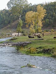 Getik State Sanctuary
 -
 Getik State Sanctuary
 -
 WWII monument in Getik
 -
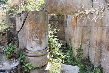 Hin Getik Monastery
 -
 Hin Getik Monastery


References
- ^ Statistical Committee of Armenia. "The results of the 2011 Population Census of Armenia" (PDF).
- ^ Kiesling, Brady; Kojian, Raffi (2005). Rediscovering Armenia: Guide (2nd ed.). Yerevan: Matit Graphic Design Studio. p. 84. ISBN 99941-0-121-8.
External links
Wikimedia Commons has media related to Getik, Gegharkunik.
- Kiesling, Brady (June 2000). Rediscovering Armenia: An Archaeological/Touristic Gazetteer and Map Set for the Historical Monuments of Armenia (PDF). Archived (PDF) from the original on 6 November 2021.
- v
- t
- e
Capital: Gavar

- Akhpradzor
- Akunk
- Areguni
- Arpunk
- Avazan
- Ayrk
- Azat
- Daranak
- Geghakar
- Geghamabak
- Geghamasar
- Jaghatsadzor
- Kakhakn
- Karchaghbyur
- Khachaghbyur
- Kut
- Kutakan
- Lchavan
- Lusakunk
- Makenis
- Mets Masrik
- Nerkin Shorzha
- Norabak
- Norakert
- Pambak
- Pokr Masrik
- Shatjrek
- Shatvan
- Sotk
- Torfavan
- Tretuk
- Tsovak
- Vanevan
- Verin Shorzha
- Zariver
Portal:
 Geography

 | This article about a location in Gegharkunik Province, Armenia is a stub. You can help Wikipedia by expanding it. |
- v
- t
- e


