Champsecret
You can help expand this article with text translated from the corresponding article in French. (December 2008) Click [show] for important translation instructions.
- View a machine-translated version of the French article.
- Machine translation, like DeepL or Google Translate, is a useful starting point for translations, but translators must revise errors as necessary and confirm that the translation is accurate, rather than simply copy-pasting machine-translated text into the English Wikipedia.
- Do not translate text that appears unreliable or low-quality. If possible, verify the text with references provided in the foreign-language article.
- You must provide copyright attribution in the edit summary accompanying your translation by providing an interlanguage link to the source of your translation. A model attribution edit summary is
Content in this edit is translated from the existing French Wikipedia article at [[:fr:Champsecret]]; see its history for attribution. - You may also add the template
{{Translated|fr|Champsecret}}to the talk page. - For more guidance, see Wikipedia:Translation.
Commune in Normandy, France
Champsecret | ||
|---|---|---|
Commune | ||
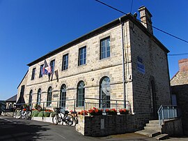 The town hall in Champsecret | ||
Location of Champsecret  | ||
(2020–2026) Julien Corbière[1] | | |
| Area 1 | 44.68 km2 (17.25 sq mi) | |
| Population (2021)[2] | 938 | |
| • Density | 21/km2 (54/sq mi) | |
| Time zone | UTC+01:00 (CET) | |
| • Summer (DST) | UTC+02:00 (CEST) | |
| INSEE/Postal code | 61091 /61700 | |
| Elevation | 140–313 m (459–1,027 ft) (avg. 300 m or 980 ft) | |
| 1 French Land Register data, which excludes lakes, ponds, glaciers > 1 km2 (0.386 sq mi or 247 acres) and river estuaries. | ||
Champsecret (French pronunciation: [ʃɑ̃səkʁɛ] ⓘ) is a commune in the Orne department in north-western France.
Geography
The commune is made up of the following collection of villages and hamlets, La Chesnaie, Les Fourchets, La Botellerie, Le Hamel, Le Tertre, Pont de Pierre, La Noé, La Basse Verrerie, L'Ermitage and Champsecret.[3]
It is 4,470 hectares (17.3 sq mi) in size. The highest point in the commune is 215 metres (705 ft).
The commune is within the Normandie-Maine Regional Natural Park.[4]
The Andainette and the Varenne are the two rivers, running through this commune.
Neighbouring communes[3] | ||||||||||||||||
|---|---|---|---|---|---|---|---|---|---|---|---|---|---|---|---|---|
| ||||||||||||||||


Points of interest
- Arboretum de l'Étoile des Andaines - Created in 1947 this arboretum features over 70 hardwood and Conifer trees.
National heritage sites
The Commune has four buildings and areas listed as a Monument historique.[5]
- Forges de Varennes the site features a blast furnace built in 1767, a refinery and a splitting mill, it was registered as a monument in 1987.[6]
- Champsecret Church a seventeenth century church, registered as a Monument historique in 1984.[7]
- Cross of the old cemetery a sixteenth century hexagonal granite cross, registered as a Monument historique in 1938.[8]
- Old manor a fourteenth century manor, registered as a Monument historique in 1926.[9]
Notable People
- Charles Lucien Léandre - (1862–1934) was a French caricaturist and painter, who was born here, and later buried here.[10][11]
- Auguste-François Maunoury - (1811–1898) was a Catholic Hellenist and exegete, who was born here.[12]
See also
References
- ^ "Répertoire national des élus: les maires". data.gouv.fr, Plateforme ouverte des données publiques françaises (in French). 9 August 2021.
- ^ "Populations légales 2021" (in French). The National Institute of Statistics and Economic Studies. 28 December 2023.
- ^ a b "Champsecret · 61700, France". Champsecret · 61700, France.
- ^ "rapport de charte" (PDF), parc-naturel-normandie-maine.fr/
- ^ "Les Monuments Historiques en Orne - 61". monumentum.fr.
- ^ "Forges de Varennes à Champsecret - PA00110771". monumentum.fr.
- ^ "Eglise à Champsecret - PA00110770". monumentum.fr.
- ^ "Croix de l'ancien cimetière à Champsecret - PA00110769". monumentum.fr.
- ^ "Vieux manoir à Champsecret - PA00110772". monumentum.fr.
- ^ "Charles Lucien Léandré | Smithsonian American Art Museum". americanart.si.edu.
- ^ "61 - PATRIMOINE FUNERAIRE DE L'ORNE : Etat des lieux - Cimetières de France et d'ailleurs". www.landrucimetieres.fr.
- ^ "Champsecret. La promotion de la ville se fait en peinture". alencon.maville.com.
Wikimedia Commons has media related to Champsecret.
- v
- t
- e

- L'Aigle
- Alençonpref
- Almenêches
- Appenai-sous-Bellême
- Argentansubpr
- Les Aspres
- Athis-Val de Rouvre
- Aube
- Aubry-le-Panthou
- Aubusson
- Auguaise
- Aunay-les-Bois
- Aunou-le-Faucon
- Aunou-sur-Orne
- Les Authieux-du-Puits
- Avernes-Saint-Gourgon
- Avoine
- Avrilly
- Bagnoles de l'Orne Normandie
- Bailleul
- Banvou
- Barville
- Bazoches-au-Houlme
- Bazoches-sur-Hoëne
- La Bazoque
- Beaufai
- Beaulieu
- Beauvain
- Belfonds
- Belforêt-en-Perche
- Bellavilliers
- Bellême
- La Bellière
- Bellou-en-Houlme
- Bellou-le-Trichard
- Berd'huis
- Berjou
- Bizou
- Boëcé
- Boischampré
- Boissei-la-Lande
- Boitron
- Bonnefoi
- Bonsmoulins
- Le Bosc-Renoult
- Boucé
- Le Bouillon
- Brethel
- Bretoncelles
- Brieux
- Briouze
- Brullemail
- Buré
- Bures
- Bursard
- Cahan
- Caligny
- Camembert
- Canapville
- Carrouges
- Ceaucé
- Le Cercueil
- Cerisé
- Cerisy-Belle-Étoile
- Ceton
- Chahains
- Chailloué
- Le Chalange
- Champcerie
- Le Champ-de-la-Pierre
- Les Champeaux
- Champeaux-sur-Sarthe
- Champ-Haut
- Champosoult
- Champsecret
- Chandai
- Chanu
- La Chapelle-au-Moine
- La Chapelle-Biche
- La Chapelle-Montligeon
- La Chapelle-près-Sées
- La Chapelle-Souëf
- La Chapelle-Viel
- Charencey
- Le Château-d'Almenêches
- Le Châtellier
- Chaumont
- La Chaux
- Chemilli
- Ciral
- Cisai-Saint-Aubin
- Colombiers
- Comblot
- Commeaux
- Condé-sur-Sarthe
- Corbon
- Coudehard
- Coulimer
- Coulmer
- Coulonces
- La Coulonche
- Coulonges-sur-Sarthe
- Courgeon
- Courgeoût
- Cour-Maugis sur Huisne
- Courtomer
- Craménil
- Croisilles
- Crouttes
- Crulai
- Cuissai
- Dame-Marie
- Damigny
- Domfront en Poiraie
- Dompierre
- Durcet
- Échalou
- Échauffour
- Écorcei
- Écorches
- Écouché-les-Vallées
- Écouves
- Essay
- Faverolles
- Fay
- Feings
- La Ferrière-au-Doyen
- La Ferrière-aux-Étangs
- La Ferrière-Béchet
- La Ferrière-Bochard
- Ferrières-la-Verrerie
- La Ferté-en-Ouche
- La Ferté-Macé
- Flers
- Fleuré
- Fontaine-les-Bassets
- Francheville
- La Fresnaie-Fayel
- Fresnay-le-Samson
- Gacé
- Gandelain
- Gâprée
- Les Genettes
- La Genevraie
- Giel-Courteilles
- Ginai
- Godisson
- La Gonfrière
- Gouffern en Auge
- Le Grais
- Guêprei
- Guerquesalles
- Habloville
- Hauterive
- Héloup
- L'Hôme-Chamondot
- Igé
- Irai
- Joué-du-Bois
- Joué-du-Plain
- Juvigny-sur-Orne
- Juvigny Val d'Andaine
- Lalacelle
- Laleu
- La Lande-de-Goult
- La Lande-de-Lougé
- La Lande-Patry
- La Lande-Saint-Siméon
- Landigou
- Landisacq
- Larré
- Lignères
- Lignou
- Loisail
- Longny les Villages
- Lonlay-l'Abbaye
- Lonlay-le-Tesson
- Lonrai
- Lougé-sur-Maire
- Louvières-en-Auge
- Macé
- La Madeleine-Bouvet
- Le Mage
- Magny-le-Désert
- Mahéru
- Mantilly
- Marchemaisons
- Mardilly
- Mauves-sur-Huisne
- Médavy
- Méhoudin
- Le Mêle-sur-Sarthe
- Le Ménil-Bérard
- Le Ménil-Broût
- Le Ménil-Ciboult
- Le Ménil-de-Briouze
- Ménil-Erreux
- Ménil-Froger
- Ménil-Gondouin
- Le Ménil-Guyon
- Ménil-Hermei
- Ménil-Hubert-en-Exmes
- Ménil-Hubert-sur-Orne
- Le Ménil-Scelleur
- Le Ménil-Vicomte
- Ménil-Vin
- Les Menus
- Le Merlerault
- Merri
- La Mesnière
- Messei
- Mieuxcé
- Moncy
- Montabard
- Montchevrel
- Montgaudry
- Montilly-sur-Noireau
- Montmerrei
- Mont-Ormel
- Montreuil-au-Houlme
- Montreuil-la-Cambe
- Les Monts d'Andaine
- Montsecret-Clairefougère
- Monts-sur-Orne
- Mortagne-au-Perchesubpr
- Mortrée
- La Motte-Fouquet
- Moulins-la-Marche
- Moulins-sur-Orne
- Moutiers-au-Perche
- Neauphe-sous-Essai
- Neauphe-sur-Dive
- Nécy
- Neuilly-le-Bisson
- Neuville-sur-Touques
- Neuvy-au-Houlme
- Nonant-le-Pin
- Occagnes
- Ommoy
- L'Orée-d'Écouves
- Orgères
- Origny-le-Roux
- Pacé
- Parfondeval
- Le Pas-Saint-l'Homer
- Passais Villages
- Perche en Nocé
- Perrou
- Pervenchères
- Le Pin-au-Haras
- Le Pin-la-Garenne
- Planches
- Le Plantis
- Pointel
- Pontchardon
- Pouvrai
- Putanges-le-Lac
- Rai
- Rânes
- Rémalard en Perche
- Le Renouard
- Résenlieu
- Réveillon
- Ri
- Rives d'Andaine
- La Roche-Mabile
- Roiville
- Rônai
- Rouperroux
- Sablons-sur-Huisne
- Sai
- Saint-Agnan-sur-Sarthe
- Saint-André-de-Briouze
- Saint-André-de-Messei
- Saint-Aquilin-de-Corbion
- Saint-Aubin-d'Appenai
- Saint-Aubin-de-Bonneval
- Saint-Aubin-de-Courteraie
- Saint-Bômer-les-Forges
- Saint-Brice
- Saint-Brice-sous-Rânes
- Saint-Céneri-le-Gérei
- Saint-Christophe-de-Chaulieu
- Saint-Clair-de-Halouze
- Saint-Cyr-la-Rosière
- Saint-Denis-sur-Huisne
- Saint-Denis-sur-Sarthon
- Sainte-Céronne-lès-Mortagne
- Sainte-Gauburge-Sainte-Colombe
- Sainte-Honorine-la-Chardonne
- Sainte-Honorine-la-Guillaume
- Saint-Ellier-les-Bois
- Sainte-Marguerite-de-Carrouges
- Sainte-Marie-la-Robert
- Sainte-Opportune
- Sainte-Scolasse-sur-Sarthe
- Saint-Evroult-de-Montfort
- Saint-Evroult-Notre-Dame-du-Bois
- Saint-Fraimbault
- Saint-Fulgent-des-Ormes
- Saint-Georges-d'Annebecq
- Saint-Georges-des-Groseillers
- Saint-Germain-d'Aunay
- Saint-Germain-de-Clairefeuille
- Saint-Germain-de-la-Coudre
- Saint-Germain-de-Martigny
- Saint-Germain-des-Grois
- Saint-Germain-du-Corbéis
- Saint-Germain-le-Vieux
- Saint-Gervais-des-Sablons
- Saint-Gervais-du-Perron
- Saint-Gilles-des-Marais
- Saint-Hilaire-de-Briouze
- Saint-Hilaire-le-Châtel
- Saint-Hilaire-sur-Erre
- Saint-Hilaire-sur-Risle
- Saint-Jouin-de-Blavou
- Saint-Julien-sur-Sarthe
- Saint-Lambert-sur-Dive
- Saint-Langis-lès-Mortagne
- Saint-Léger-sur-Sarthe
- Saint-Léonard-des-Parcs
- Saint-Mard-de-Réno
- Saint-Mars-d'Égrenne
- Saint-Martin-d'Écublei
- Saint-Martin-des-Landes
- Saint-Martin-des-Pézerits
- Saint-Martin-du-Vieux-Bellême
- Saint-Martin-l'Aiguillon
- Saint-Michel-Tubœuf
- Saint-Nicolas-des-Bois
- Saint-Nicolas-de-Sommaire
- Saint-Ouen-de-Sécherouvre
- Saint-Ouen-le-Brisoult
- Saint-Ouen-sur-Iton
- Saint-Patrice-du-Désert
- Saint-Paul
- Saint-Philbert-sur-Orne
- Saint-Pierre-d'Entremont
- Saint-Pierre-des-Loges
- Saint-Pierre-du-Regard
- Saint-Pierre-la-Bruyère
- Saint-Quentin-de-Blavou
- Saint-Quentin-les-Chardonnets
- Saint-Roch-sur-Égrenne
- Saint-Sauveur-de-Carrouges
- Saint-Sulpice-sur-Risle
- Saint-Symphorien-des-Bruyères
- Saires-la-Verrerie
- Le Sap-André
- Sap-en-Auge
- Sarceaux
- Sées
- La Selle-la-Forge
- Semallé
- Sévigny
- Sevrai
- Soligny-la-Trappe
- Suré
- Tanques
- Tanville
- Tellières-le-Plessis
- Tessé-Froulay
- Ticheville
- Tinchebray-Bocage
- Torchamp
- Touquettes
- Tournai-sur-Dive
- Tourouvre au Perche
- Trémont
- La Trinité-des-Laitiers
- Trun
- Val-au-Perche
- Valframbert
- Vaunoise
- Les Ventes-de-Bourse
- La Ventrouze
- Verrières
- Vidai
- Vieux-Pont
- Villedieu-lès-Bailleul
- Villiers-sous-Mortagne
- Vimoutiers
- Vitrai-sous-Laigle
- Les Yveteaux
- pref: prefecture
- subpr: subprefecture
Authority control databases | |
|---|---|
| International |
|
| National |
|
 | This Orne geographical article is a stub. You can help Wikipedia by expanding it. |
- v
- t
- e


